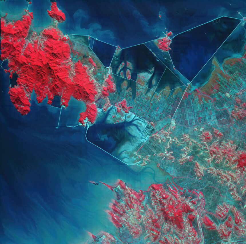
Nine months after the launch of its first satellite, Bellevue, Wash.-based Xplore is sharing a hyperspectral view of North Korean territory as seen from orbit.
The image, captured in visible and near-infrared wavelengths by Xplore’s XCUBE-1 satellite, was unveiled today at the Seattle Space Superiority Summit at the Museum of Flight. Xplore’s co-founder and chief operating officer, Lisa Rich, said the picture shows “semi-submerged farms that are likely rice paddies,” plus fish farms and salt flats.
“This is a big reveal for us today,” Rich said.
XCUBE-1 was sent into low Earth orbit last December as part of SpaceX’s Bandwagon-2 satellite rideshare mission. Xplore began sharing imagery from the satellite in June.
XCUBE-1’s images have a resolution of 5 meters (16 feet) per pixel, and are typically shown in false colors to accentuate differences in terrain. For example, shades of red are used to indicate vegetation. “We’re seeing more than we expected to see,” Rich said.
Over the course of repeated flyovers, such images can track the construction of new facilities or other changes in surface features. That can provide valuable insights for intelligence agencies.
Xplore is one of six companies providing hyperspectral satellite data to the National Reconnaissance Office under the terms of five-year contracts awarded in 2023.
The contracts are part of NRO’s multi-stage effort to learn more about the utility of hyperspectral imagery. The first stage focuses on analytical studies to provide estimates of system capabilities at both the individual sensor and constellation levels, as well as business and cybersecurity planning. The second stage focuses on assessing on-orbit capabilities and procuring data products.
Providing data for national security purposes is just one of the applications that Xplore is targeting for its “Space as a Service” business model. The company, which was founded in 2017, is also developing satellites and orbital platforms for commercial remote sensing.
Read the full article here